| Day 13 Profile |
|
 MapSource |
 Google Maps Terrain |
I got up before dawn today. 5:30. I wanted to be hiking at first light. I knew today was going be a long day. I was hiking by 6:40. As I started hiking, I passed by a campsite that had lawn chairs, a folding picnic table, a large tent, and other heavy odd and ends. What?? Then I saw the Llamas. OK, now I understand. Not sure I would want to use a Llama for any long hike, but what a blast for a short hike and long camp type of trip!
Sunrise on Palisade Creek Canyon
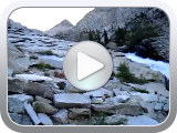
Bottom of Golden Staircase looking up
Top of Golden Staircase
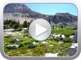
The trail soon started to climb steeply, and there were switchbacks galore. The canyon I was in looked like a box canyon with no way out except the way I had just come. Sure enough, I had reached the "Golden Staircase". Several times during the ascent I looked up and thought "No way there is a trail up there". I think it is called the Golden Staircase due to the tons of gold it took to pay to carve that trail out of the mountain. It was pretty unique. Soon I came to the Palisade Lakes. It was getting close to the treeline level so vegetation was limited but still enough green to provide life and contrast. There was some snow at this elevation and the combination of blue sky, blue lakes, snow and bare mountains as a backdrop was gorgeous.
Lower Palisade Lake
Upper Palisade Lake looking toward Mather Pass
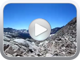
Mather Pass
Mather Pass looking towards Palidade Lakes
I continued to climb up past the lakes and on to Mather Pass. The trail over the pass was really not difficult, but I completely hit a wall at this point and had zero energy. My lack of dinner last night caught up with me. The pass itself did have some snow, but nothing scary. The terrain looked like a barren moon for as far as the eye could see. After the switchbacks down the South side the trail was easy. I stopped just before the South Fork Kings River crossing to make camp (Wenk site 9.03). I only saw 2 people all day today. I tried the "Ostentatious Tortilla Soup" from Pack-It Gourmet for dinner. OK, I can eat this. Really good!!! Not so good was the moskies. Bad!! I did a full suit-up in my rain gear and headnet to keep them at bay. 11.7 miles today. Hiked from 6:40 to 4:00pm.

Mather Pass
Mather Pass

Mather Pass
Pinchot Pass tomorrow. Looks easy though. It doesn't look like I lose much elevation between Mather and Pinchot so the climb should be fairly easy. We will see.
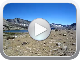
Just after descending the south side of Mather Pass
Beauty at 11,000 ft
| Previous Day |
Next Day |
 |
 |