Day 3 route

Day 3 elevation profile


Day 3 route |
Day 3 elevation profile |
9/6/2012
53 low, 66 high
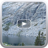
2700 ft ascent today. Climbed to Precipice Lake. It was cloudy so the pictures may not convey just how amazing this lake is. Totally cool.
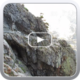
Then, climb, climb up to Kaweah Gap. Loved it. You can see the Great Western Divide in both directions for what seems like an eternity.
On the way to Kaweah Gap, the trail had to be carved through a tunnel, and in some spots you can see the underside support (or lack of) of sections of the trail. Pretty scary...
Descent to Big Arroyo. For some reason, it was slow going. Took me 7 hours... My map said 6 miles, my GPS said 8 miles. Felt like 8.
I was tired by the time I got there, and made camp at 2:00 pm. Ramen for dinner. I am still eating OK. Rinsed off in the river. Met two hikers from New York, who had hiked in from Mineral King.
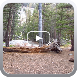
Met a total of 8 people today. Much quieter than Bearpaw or Hamilton Lake! I found a really nice campsite in the woods by the river. No bugs!
The plan for tomorrow is to hike to Moraine Lake, around 8 miles. TarpTent was hard to setup. Rock ground with no way to stake it except using rocks.
It was cloudy all day, then cleared up around 4pm.
Previous Day
Next Day
Day 3 Videos